Filming Sites/Locations

Emma

Dedicated Member
Can anyone identify the structure in this episode where Blamire, Clegg, and Compo meet with Shep, the Lollipop man? Shep was played by Jack Woolgar. Compo finds his initials carved inside the structure, and the group teases him about having been in love with Aggie Duckett.

I would also like to know about the building site in the episode "The Empire That Foggy Nearly Built." The group seeks out waste spaces for use as parking lots (car parks), and come across what looks to be an abandoned building site.

Thanks in advance for any assistance with this.
 
Hi Emma, welcome to the madhouse:08::confused:

I stand ready to be corrected but I think the structure you are looking for has now been pulled down, but I believe it was in Victoria Park in Holmfirth itself, overlooking the centre of town.
as for the other site, if you look at the summerwine map on the main tabs of this website you will find a link to a google earth map which has heaps of locations pinpointed for you, including that one.

Cheers

Brian
 
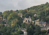
Emma — When you finally get a chance to visit Holmfirth, you'll probably feel right at home because most of the buildings, streets and views will look very familiar. When I was there for a few days in 2015, I walked up New Fold and Goose Green to come out where Compo and Blamire meet near the beginning of the pilot episode. I could almost see and hear the characters. After continuing up Cartworth Road far enough to photograph the gate that we saw Blamire come out of with his landlady's dog, and then a bit further for a good view of St John's, Upperthong on the hill opposite, I walked down Rotcher Road, where we saw Blamire walking down with his camera in "Hail Smiling Morn or Thereabouts"

Here's the photo of St John's:
St Johns from Royd Mount.jpg

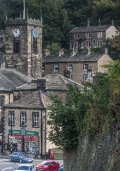
And here's one of Victoria Square and the parish church with one of Clegg's houses at the upper right, taken from nearly all the way down Rotcher Road, cropped to use as wallpaper on my phone:
Holmfirth for phone wallpaper.jpg
I'll be back in Holmfirth for a week in September, and hope to find a different angle for this one that eliminates most of the retaining wall and shrubbery on the right, but this will do in the interim.

I also plan to take the Huddersfield/Holme bus from Holmfirth to Holme and walk the very short distance to Bilbury and Digley Reservoirs. There's a footpath around Digley Reservoir that crosses the upper end via the Bilbury Dam. I'll probably also stroll up Meal Hill to the school that was used as background in several episodes, then a bit further up to look at the hill where we see "[By] The Magnificent Thighs Of Ernie Burniston" first on a bicycle, then running.

The local bus system is pretty good for getting tourists close to scenic locations, many of them used in LOTSW.
 
Yes. It's gone. The inside shots were done in a studio I think. The actual building didn't have seats inside when I saw it. The derelict site is now occupied by business premises.
 
Yes. It's gone. The inside shots were done in a studio I think. The actual building didn't have seats inside when I saw it. The derelict site is now occupied by business premises.

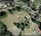
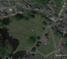
Here are aerial photos from Google Earth showing the site in 2001 and 2016:
Victoria Park 2001.jpg Victoria Park 2016.jpg
In addition to removing the stone structure, they must have brought in quite a lot of fill in order to create a smooth slope from where the back of it was embedded in the slope down to where the open front overlooked the town. At the same time, they removed the grass and shrubs from the semi-circular area on the other side of the access road, paving it for who knows what reason.

The stone was a doorway at Yateholme, rescued from flooding before the Yateholme Reservoir was built. http://www.examiner.co.uk/news/local-news/holme-villages-fascinating-history-7079658 mentions, "... the door arch at the other playground entrance up Meal Hill Road [Holme] has had a more interesting history, for it came from a building in the Domesday-listed village of Yateholme, sacrificed for the construction of a reservoir.

This door arch, which stood in Victoria Park, Holmfirth for many years, was moved several years ago and in 2012 was placed at the second playground entrance with an explanatory plaque built into the wall alongside."

The Google Earth street view of that playground dates from 2009, before the structure was placed there, but I plan to walk up that road to the school when I'm in the area in September, so I'll look for it then.
 
Thanks so much for this information, and the photos. It is sad news that the structure that was built into the side of that hill is gone. It was shown at least twice in LOTSW series, and I wondered about its history, and what had been the original purpose.

I don't know why I have been so taken by this show, but it has remained one of my all-time favorites. When my Public Television station began airing weekly episodes, they started with the introduction of Brian Murphy's character, Alvin Smedley. It wasn't until many years later that they received rights to air the series in its entirety. Four episodes were aired each week, and I was able to watch every one. I only wish I had known they would only air the series on a one-time basis. Since that time, it has gone back to repeating a few random weekly episodes that I already have on video.

It is difficult to get a sense of direction from the photos I saw. I'd like to know where specific locations are in relation to main landmarks. I suppose I would have to see a kind of LOTSW Map to the Stars, as it were, or be there in person. I did request visitor's information, which included a map, but I have never received it. Not many of the main characters drove cars, so it looked like things were within walking distance. I know it's a TV show, and they were transported to locations, but I'm just curious about where certain sites are in relation to others. I wonder if Nora's house is across the water from Edie's house? Is the Cafe on a main street? It seems to be located in a valley, since it has two sets of steps close by. Where was Norman Clegg's first house? He lived next to Howard and Pearl Sibshaw, then they were relocated and continued to be neighbors.

There are very few television shows worth watching on American TV. Even the programming on BBC-America has little to offer. I don't like Dr. Who or Star Trek; and I have no idea why Star Trek is even on a British station.

My love affair with British movies and television began in the early 1970s. I have been a dedicated fan of British comedy and drama for decades. They are well-written, the actors are talented, and look like real people - instead of the too pretty, too perfect, fake Hollywood-types. Your writers are able to tell a story in which viewers come to care about the characters, and can become involved in the plot. All this without resorting to car chases, explosions, mass killings, and vulgarity, which seems to be must-haves for American film writers, and those who create our TV shows.

I truly hope I am able to see the areas of England I have seen on TV and read about (I'm also a Jane Austen fan) before I am too old and unable to travel. Thanks again, for your kindness in passing along this information.
 
I suppose I would have to see a kind of LOTSW Map to the Stars,
Emma there is a map which Terry produced so at the top of the page you will see a link Main Website if you click that it takes you to the main Summer Wine Website on which there is a pull down menu under Summer Wine pages one item of which is Maps . If you click it that takes you to the map page and embedded in the text is a link to the Summerwine map that takes you to Terry's map on which there are numerous locations where they filmed.

In addition if you click the Home button at the top of the screen and scroll down to Photo Corner and select a spot of Member's photos within that there are all sorts of photos about the locations and show. I must point out that the individual threads set up by Pete are really good because Pete lives close to Holmfirth and has kindly taken time out on several occasions to extract photos from a particular scene in the show and has then photographed the location as it is today spelling out where it is . The photos are well worth spending time on .

Hope this helps.
Thank you!
 
It is difficult to get a sense of direction from the photos I saw. I'd like to know where specific locations are in relation to main landmarks. I suppose I would have to see a kind of LOTSW Map to the Stars, as it were, or be there in person.

See the Summerwine Map link, just under the Forums tab in the toolbar at the top of the page. There are currently 290 locations marked on it, so there are clusters of pins piled on one another in some areas. You can zoom in to spread the pins out, so you can click on just one to see the description. Or you can start from the list of pin "titles" to go to a particular location. When you select a location, you'll see a bent arrow in the red title bar at the top of the description. Click that to go to another version of Google maps showing your selected pin and allowing you to drag and drop the little human into street view at the pin location. You can toggle between aerial and map view on both maps.

To see where I was standing when I made the photo of St John's church, go to the location named "Pilot Episode", then go south-east up the hill to the next street. I was standing directly across from the house where Blamire lodged and facing a bit north of due west toward "Compo's Church".

When I made the photo of Victoria Square, the church and Clegg's/Howard's house, I was standing at the "Uncle of the Bride" location facing the actual location of the house, due east and a couple of steps north of the "Cleggy & Howard" location.

Where was Norman Clegg's first house? He lived next to Howard and Pearl Sibshaw, then they were relocated and continued to be neighbors.

Click on "Cleggy & Howard" in the locations list to get close to the house that you're probably thinking of, then go east and north as described above. The one used for Clegg's house in the early series isn't marked on the map and the location is very difficult to describe, so here's a screen grab from Google Earth as far as I can determine based on a long-ago conversation with Terry on this forum. I added the label "Clegg's?" on the roof.
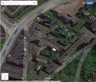
Possibly Clegg's first house.jpg
The image is oriented conventionally (North at the top). You can find it on the Summerwine Map by matching the road names and the marked businesses, then you can see it's relationship to the marked locations nearby. I'd love to make a photo of it, but the access to it is very private so that's probably impossible.

I wonder if Nora's house is across the water from Edie's house?

Nora's house is in Holmfirth, on Scarfold. Edie's house is about 1.2 miles up Woodhead Road, then turn left and cross the river. See "Nora & Compo's" and "Edi & Wesley" in the locations list.

Is the Cafe on a main street? It seems to be located in a valley, since it has two sets of steps close by.

The contours are complicated there because it's very near the intersection of two river valleys, the River Ribble and the River Holme. Again, see the locations map. The long flight of steps comes down the hill to the east and the short flight comes down the hill to the south. The cafe is one of the buildings on the south side of Church Yard. Another cafe, Beatties, is on the east side, and the side of the parish church is directly across from Sid's. As you walk out the door and turn left you pass the side of the hardware store before reaching the fourth side of the yard, which is open to the street (Town Gate) where there are a couple of shallow steps down to sidewalk level. That's because when the 1476 stone church was swept away by the 1777 flood, the parishioners raised the area up on a plinth and located the door at 90 degrees to the street to protect the building from future floods. The strategy worked — the building has suffered little or no damage in subsequent floods.
 
Last edited:
To summarize, many of the locations that seem to be within walking distance are actually very distant except that Clegg's and Howard's first houses are visible up on a hill in many photos and Sid's Cafe is on a main street nearby. As Holmfirth began to be difficult to film in they started to film in nearby Marsden which has a very distinctive clock tower, and a canal with a red metal fence where many scenes were filmed. Outdoor scenes of Auntie Wainwright's shop were also filmed in Marsden.
 
... they started to film in nearby Marsden which has a very distinctive clock tower, and a canal with a red metal fence where many scenes were filmed.

The Huddersfield Narrow Canal passes through Marsden north of the filming area for the most part. The waterway and red railings with which we're the most familiar is the River Colne where it runs beside Weir Side.
 
Last edited:
This site has a real wealth of information, and you can't imagine how happy I am to have found it. I spent more than an hour going through some of the pinpoints to go exploring. It gave me a feeling of urgency, and I should make an effort to visit these areas while most are still recognizable.

Thanks again, everyone. I appreciate your welcoming manner, and the information you have provided.
 
I believe Clegg's and Howard's house were further up the hill - actually backing onto Bunker Hill.

Yes, the pin is on the underdwelling side of the building whose overdwellings face on Church Terrace. If you move due East from the pin until you reach the space between two buildings on Back Lane, then move North to the larger of those buildings, you'll be at Howard and Pearl's end of the terrace.
 
The front of the terrace overlooks Bunkers Hill just about at the point where the road curves and the name changes to Church Terrace. The back wall is right up against the edge of Back Lane, the address is 50-54 Back Lane, and access to the entrances is via a gate off back lane leading to a footpath along the end wall of the building.
 
I was close on this location, but no cigar, because the locations for Small Tune ... and Hail Smiling Morn ... were two different houses.

Take a look at the very end of Small Tune on a Penny Wassail, the terrace and house behind the credits. Then see the two exterior photos here: http://www.cottages.com/cottages/shelduck-cottage-ukc848. Of course, after all these years and with increased prosperity the terrace is heavily decorated, but you can still recognize the railing on the side where the cobbled street comes up from Daisy Lane into St Anne's Square, as well as the stone retaining wall on the opposite of the terrace. Also, the front door with small rectangular window and transom over, single window to the right of the door as you're facing it.

When the camera pulls back, we can see part of the slate roof on the southeastern-most building of the ones at right angles behind the Cornerhouse Cafe.

They used a different house in Hail Smiling Morn ...; a semi-detached, possibly the one I labeled "Cleggs?" in the comment quoted below. Those two locations are only about 25 yards apart as the crow flies.

Click on "Cleggy & Howard" in the locations list to get close to the house that you're probably thinking of, then go east and north as described above. The one used for Clegg's house in the early series isn't marked on the map and the location is very difficult to describe, so here's a screen grab from Google Earth as far as I can determine based on a long-ago conversation with Terry on this forum. I added the label "Clegg's?" on the roof.
View attachment 1402
The image is oriented conventionally (North at the top). You can find it on the Summerwine Map by matching the road names and the marked businesses, then you can see it's relationship to the marked locations nearby. I'd love to make a photo of it, but the access to it is very private so that's probably impossible.
 
Back
Top